


We are up bright and early as we have three passes to go over today and one of them is Stanton Pass which is considered to be one of the hardest on the Sierra High Route. The High Sierra Topix (online adventure community) describes the south side of Stanton Pass as “tricky mess of class 3 shelves”. Talusfield says this about the north side of Stanton Pass: “descend carefully as this is perhaps the trickiest terrain on the SHR”.

Ok, so both the north and south sides are challenging. Walking With Wired who is well known for her blog and many thru-hikes says she was “too freaked out to take many photos, but doing some of these things with a pack on is just frightening for me.”

So I have been thinking about this pass for a while. This is the true test and under normal circumstances for us would have been the climax, grande finale of the trip. But this won’t be the grande finale for us. We had to bypass a 50-mile section starting at Mammoth Lakes because of the Lion’s Fire. We are still planning to go back to hike that section this season (assuming the Lion’s Fire dies down to a smolder and the USFS opens the Becks Lake Trail). So this won’t be the final big push. But it still feels like the big cahuna; this last part is one of the hardest sections. It will test our skills and abilities.
The first pass we go over, Grey Butte Pass, is a yawner in terms of passes on the Sierra High Route. But it is a confidence booster for what lies ahead. Grey Butte Pass is only 300 feet above where we camped last night at Soldier Lake. The views are great but we can see Stanton Pass in the distance. It looks steep.
By now Ray and I are getting pretty good at reading terrain. There are a few ramps on the left side of Stanton Pass that look like they could go. We pick a route that goes up a ramp. The ramp looks like it goes to the top of the ridge, just left of the saddle with a small amount of exposure. Ray and I follow this line and pick our way up the pass. It is not too bad, a few little exposure spots near the top but all doable.
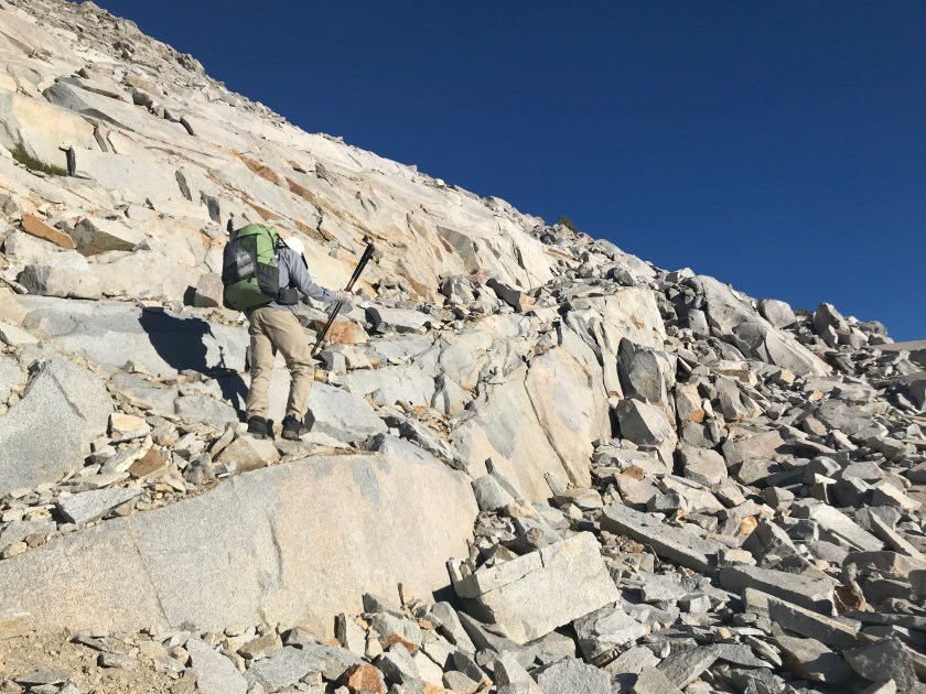
At the ridge, the best way we found to get down was following the notes from Talusfield. The route is about 300 left (or southwest) along the ridge and then down about 100 feet down along a steep ramp of about 60 degrees. Ray goes down first and is able to go back and forth across the ramp using cracks that cut across to keep from sliding. My heart pounds as I watch him as I say positive mantras to myself: “I am strong, I can do this, my shoes have really grippy soles”…everything I can think of. Luckily it works and although challenging, it is short.


From the talus slopes on the north side of Stanton Pass we drop down into Spiller Creek. The Spiller Creek drainage is a sharp change from the ruggedness of Stanton Pass, cupping us in it’s hands of gentle topography and meadows that beg us to skip through them singing the hills are alive. Sometimes it is this contrast in landscape that grabs your attention; the bipolar nature of life itself.

After skipping through the Spiller Creek meadows, we arrive at Horse Creek Pass. We are now in an altered zone. An “altered state”, not of mind, but of landscape; veins of rock wiggling like snakes changing the rocks around them. But these snakes do not escape, their imprint left behind. I read the rock story with suspense: molten granite intruded metamorphic rocks with heat and pressure, leaving behind precious minerals and ores.


We soon forget we are hiking and like kids in a candy store begin picking up rocks, savoring the delicacy presented to us. Ray picks up a rock that has large tourmaline crystals in it. Black, shiny and prismatic, they are at least an inch long.

We marvel at these gemstones. From a geologic perspective, they are rare and are pyroelectric, meaning they produce electricity when heated. Spiritually, black tourmaline is known as a powerful protector and healer. I rub it in my hands feeling it’s power and beauty. I know it is meant to be left where it is found so I put it back down to protect and heal the area around it, and continue telling the story of it’s geologic past.

Soon we are hiking down the Horse Creek drainage and as we drop down into the creek, a trail develops and becomes more pronounced. We are now only a few miles out from Mono Village, a large resort on Twin Lakes with cabins, a 300-site campground, grocery store, boathouse, restaurant, showers and laundry.

This will be our pick up spot tomorrow and end of this section. We start seeing people, first a couple who is climbing Matterhorn, and then others who are going in to camp for a few days. This section of the Sierra High Route felt wild, at least until now. We are back with the crowds coming up from Twin Lakes. We get to Mono Village thinking we can just find a place to camp in the forest but it is not the case. Because Mono Village is a private inholding to stay here we have to pay $35 for a campsite. If we had known that, we would have stopped a few miles from the trail’s end. But we don’t want to hike back up the trail to get to National Forest land and the showers and restaurant sound appealing. We pony up the $35. Tomorrow afternoon, we will get our transportation pick up from Lew Hill who will take us back to our car at Tuolumne Meadows. Time to “freshen up”.
Post-Trip Note: This normally is the end point for the Sierra High Route but we skipped the section from Red’s Meadow to Tuolumne Meadows because of the Lion’s Fire and closure of the Becks Lake Trail. We waited a week and a half, and came back to finish the Sierra High Route from Red’s Meadow to Tuolumne Meadows after the National Forest Service opened the Beck’s Lake Trail. The section from Red’s Meadow to Tuolumne Meadows is covered in the final blog posts (days 23 through 27).
Thanks for the detailed trip description, great photos, and enlightening notes about the geology! One comment – the link to the Talusfield blog post now take you to a site that tries to install malware.
Thanks Ken for the heads up. I removed the link to Talusfield. Guess that site has changed since I used it originally.