

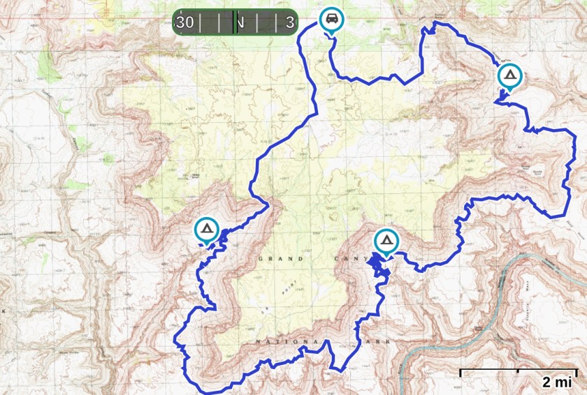
Route: this loop hike combines the route into Hades Canyon described by Todd Martin (http://www.toddshikingguide.com/GrandCanyoneering/) and traverses across the Esplanade Sandstone roughly following the Tuckup Trail to the east, where visible. The hike then exits out 150 Mile Canyon. This hike should only be attempted by experienced hikers with desert and route-finding experience and skills.

Water Management Plan: Hiking on the Esplanade Sandstone can be hot and dry unless it has recently rained. Sandstone potholes after a rain fill with water and some of them hold water for up to a week, and sometimes two. There are even a few “permanent” potholes but they are few and far between. There has not a decent rain for close to two weeks and it has been hot and dry. This part of the Esplanade is considered to be very dry and exposed, with little shade and water. We expect to get our first water in Hades Canyon where we have gotten water from a side drainage in the past.

But we don’t know how dependable this water is and whether it will even be there. There are also several springs along the Esplanade that are considered permanent: Cork Spring, Hotel Spring and Buckhorn Spring. But there is at least 15 miles of off-trail hiking between Hades Canyon and Cork Springs with no water, and at least 10 miles of mostly off-trail hiking between Cork Spring and Hotel Spring with no water.

Our plan: hike into Hades Canyon and check for pothole water. If it is dry, it is not the time for this hike and we turn around and head back out the same route. If there is water, stay overnight in Hades, tank up in the morning, and head to Cork Spring with at least 4 liters of water each. Also, we adjusted our permit based on weather patterns (done at Pipe Spring National Monument the day before we started the hike). We wait an extra day as a cold front is moving into the area and our second long, dry day to Cork Springs now falls on a cloudy day with 50% chance of precipitation and a temperature drop of 19 degrees Fahrenheit. From Cork Spring, start with four liters and head to Hotel Spring. Hike from Hotel Spring out 150 Mile canyon back to the car (where we have at least 4 gallons). We have given ourselves 4 days starting on April 28, 2019.
Daily Neat Beat Day 1: miles: 9.8, Elevation gain/loss: 778 ft/2730 ft, Camp: Hades Canyon
Last night we camped on the road to 150 Mile Canyon just past the junction of the road that goes to S B Point. This splits up the hiking on the road and above the rim between the first and last days of the loop. It is supposed to be very hot today, especially considering we are dropping several thousand feet in elevation. Our main goal today is to get down through the Kaibab, Toroweap, Coconino and Hermit Shale Formations and into Hades Canyon where we will camp tonight. We get started an hour before light as we have approximately 2.5 miles of road walking before we cut cross country to get to the route into the canyon.

I enjoy hiking in the dark along a road. We did this several times when we hiked the Hayduke Trail last year (https://wordpress.com/block-editor/post/thru.live/1311), like when we were crossing the open sage desert between Grand Canyon National Park and Zion National Park (https://wordpress.com/block-editor/post/thru.live/1916)

It is just starting to get light when we cut off the road and head cross country towards the route that will get us down through the rubble spires of Kaibab Limestone, ledges of the Toroweap Formation, and to a crack that goes through the Coconino Sandstone cliff. The timing is great but I can tell it is going to be a hot day. I am focused on getting down to the Esplanade Platform and into the shade of the Supai walls in Hades Canyon. But first, we have to turn and twist through the cliffs to get below.

The route into Hades is described well by Todd Martin. We are doing it backwards from his description: down behind the Kaibab Limestone fin and the cliff face, descend through ledges of Toroweap (this is actually fairly steep), and head southeasterly to a break in the Coconino Sandstone above “a large black rock that juts vertically into the air”.


We work our way down behind the Kaibab fin. The route drops quickly and soon we step down through steep ledges in the Toroweap Formation. Then the tricky part: we wind around a ledge above the Coconino Sandstone cliff which has a drop off of at least 400 feet. This is no place to be if you have a fear of heights! We check out several what look like possible breaks through the Coconino Sandstone but they don’t go through when you look over the edge. After several false starts, we finally find the crack through the Coconino. It is indeed above a “large black rock” described by Todd Martin. I thought the large black rock might be from a lava flow as lava flows are close by in Tuckup Canyon. This rock, though, turns out to be a house-sized piece of Kaibab Limestone with a varnished black top.


There is one spot right above the route through the Coconino Sandstone that you have to catch a ledge or you are tumbling at least for four to five hundred feet over a Coconino cliff. But we made it down without any problem and before the sun hit the canyon walls with blazing intensity.

It is scrambly and bouldery for a while down the drainage once we are in the Hermit Shale and working our way down to the Esplanade Platform. Now I am thinking about whether there will be water in Hades Canyon. I sure don’t want to go back up that route we just came down. I ponder other options if we don’t find water. We both are still pretty full at close to 4 liters of water.

If we don’t find water and have to bail, maybe we can get to the canyon north of Hades. George Steck has it marked as a way out to the rim in his classic book Grand Canyon Loop Hikes II. I know we can make it to Schmutz Spring for water if we had to but that would take us pretty far away from our truck.
Soon we are in the red walls of Hades Canyon. Despite it’s name, it is a beautiful canyon. We head to the place where we have found water before. This will dictate the rest of our trip. Yay! We find water.

It is pretty stagnant and has a yellow color before we filter but we are now happy campers! We find a place close to the canyon wall with sand and put up our tent. Then it is off to explore and it isn’t even noon yet. Time to scamper away the rest of the day!


Day 2: miles: 15.1, Elevation gain/loss: 1347 ft/1147 ft, Camp: Esplanade Platform above Cork Spring
It seems funny to adjust your trip to be out hiking when it rains but we are happy to be greeted with gray skies as we start the long trek from Hades Canyon around S B Point. We changed our permit by a day to time this long hard slog day with rain. Although it spits rain on and off all morning, it is amazing how dry everything is. On and off our raincoats come but no sign of water for drinking.

We have a few potholes marked on our Gaia app that are towards the edge of the Esplanade Platform by the “Cork”. We are hoping for water there but if not, we know we can push on to Cork Spring. At least we think we can…..

But there are no guarantees in life and even though it is raining, it is dry on the Esplanade. By late morning, we have hiked 10 miles and head towards the cliff edge to look at a few deeper potholes. No water and no luck. The wind is now blowing hard and we dive under a ledge as the rain starts coming down in earnest. It is a strange feeling to be worried about having enough water when it is pouring rain.

After a lunch break, we head towards the Cork and beyond it to the labyrinth of drainages that comprise Cork Canyon. The Cork is an interesting feature in the landscape: a reddish hill with a dark cap. The Park Service describes it as having a solitary cap of basalt and mention in the Tuckup handout “there are no visible signs of volcanism for many miles from this feature”. I wonder if it is really a volcanic plug instead of a “cap”. Maybe it is called “the Cork” as it plugged up the neck of a volcano, just like a cork in a bottle of wine. We don’t really have the time to investigate so don’t walk all the way around it or climb it. Later I research it but cannot find how “the Cork” got it’s name or how it was formed.


By mid-afternoon, it has rained long and hard enough that the drainages are beginning to flow. Ray and I gleefully collect water below a sandstone lip and fill up our 3L dirty water bags.

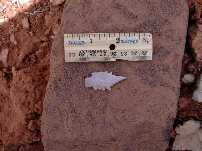
We can filter later and now don’t need to go to the Cork Spring tonight. But, of course, we want to make progress and get at least partway around Cork Canyon. It is not fast or easy hiking in this country. Ray and I are also our own worst enemies and can easily get distracted. We tend to travel fast but then stop as we are always finding something: a projectile point here, a bighorn skull there.


By 5pm, we are around the main drainage into Cork Canyon and set up camp by some potholes that, guess what, are now full.

From famish to feast, we now have plenty of water but out of curiosity, decide to hike down canyon to the spring. It is after 5pm and we should be cooking dinner but down the canyon we go. We have already hiked over 14 miles off-trail today but what the heck.

The spring has a small flow and the canyon is beautiful. It is about mile down canyon and a 200 foot drop in elevation.

We hurry back to camp and blow right by the side drainage we were supposed to take out to get back to camp so we end up winding around the top of a few more drainages. This is convoluted country.

Clouds are moving in and the wind starts to blow hard. Pretty soon we are in our tent, eating our dinner and trying to keep the side of the tent from blowing in. The rain is pounding down hard. From one extreme to the other. Were we really worried about water earlier?? It is a yin and yang of natural duality.
Day 3: miles: 10.3, Elevation gain/loss: 685 ft/943 ft, Camp: Hotel Spring
Today our main goal is to get to Hotel Springs. It is cloudy when we get started hiking. We have hiked around Boysag Point before on the Esplanade. I do not remember this part as being too hard. But, as usual, there is a lot of winding around canyon heads which always take longer than you think it will from looking at the map. We pass Steck’s Cowboy Camp and are excited to see it. I find these old cowboy camps to be almost as interesting as the archaic pictographs found on the Esplanade. Often, the cowboys used the same places used by the Native Americans as they moved through the landscape. Water, shelter and food directed their movements and ours today.
Soon we are winding around Dead Horse Mesa and turning into 150 Mile Canyon. A black-chinned hummingbird appears and starts doing these large u-shaped dives with a trill whistle at the end. No, he was not trying to impress us but a female in the area. This is part of the male’s courtship behavior. He even stops on a branch for a while. Maybe he is tired from his large swan dives. I mean, have you ever seen a hummingbird slow down or stop?


We notice many signs of past use along this route. Last time we were below Boysag Point we found an intact projectile point and a very large roasting pit (greater than 50 feet across).
I am curious to what our ancestors roasted in these big pits. This one, like others we have seen, is donut-shaped with a ring of fire-burnt Kaibab Limestone. Foods were placed in these roasting pits on heated rocks and then covered with grasses. One pit analyzed on the Bright Angel trail used to roast agaves was over 3,000 years old.

But this roasting pit is larger (50 feet across vs. 25 feet) and I can’t help but think maybe it was related to successful hunting of larger animals. Many of the Grand Canyon Polychrome or Esplanade Style pictographs we have seen include bighorn. I wonder is there is a connection.
The flowers are in full bloom this time of year. This has been a wet winter and they seem to be peaking. As we get closer to Hotel Spring we see fields of mariposa lilies in densities like I have never seen them before.
Mariposa lilies have corms which are like bulbs, only round. These can be eaten and served as a food source in the past after long, harsh winters. I wonder if you would find evidence of roasted lily corms in these large roasting pits? It is pure speculation on my part but so little research has been done on the pits.
By mid-afternoon, we reach Hotel Spring and it’s dependable water source. There is a cowboy camp here and a very faded Grand Canyon Polychrome/Esplanade Style pictograph.

I am glad to see the cowboy camp is mostly intact from when we saw it a few years ago. Someone has put a camouflage tarp in the storage box but other than that, it is about the same. You definitely get a feel for what it was like for the cowboys to have camped out here in the 1950s or so. It is important to appreciate these “outdoor museums” and leave them for others to enjoy.

Day 4: miles: 6.5, Elevation gain/loss: 2177 ft/156 ft, Camp: back at truck
The goal for the last day is to get back to the truck on the rim. We hike up the drainage in 150 Mile from Hotel Spring. Sometimes there is a trail and sometimes you are walking directly in the canyon. It is scrambly but not hard. We get to Buckhorn Spring after about 2.5 miles. Buckhorn Spring is in the drainage right before you start the climb up through the Coconino Sandstone, Toroweap Formation and Kaibab Limestone.

This is a nice stop for a drink of water and snack before the climb out. From Buckhorn Spring, it is a steep 1000 feet up in about 3/4 of a mile but the route and trail is straightforward. We are out to the top and back to the car by 9am. It is a 2 hour drive on dirt roads back to Kanab. These roads are not great to drive after a rain. Luckily for us, it has been a day and a half since the hard rains when we were down on the Esplanade. The roads are dry enough to get out.
Finally finished you story, SO MOVING ! one thing I’ve kept think was WATER is LIFE .
Thanks CJ!! So true. You know it with the places you like to hike and camp. It is good to be reminded and not to take water for granted.