

We can see the next challenge, Sky Pilot Col, from our campsite and it looks steep and ominous from our view. I read Roper’s description of the pass last night, trying to decipher his words. He describes Sky Pilot Col as “more rugged than the previous section”, a scree slope near the top that is “offensive” and a 1300-foot descent that “demands constant attention”. Hmmm…I am a little gun-shy after our scramble on the ridge of Mt. Conness yesterday. Pick your line carefully and pay attention I remind myself. If you don’t pick the right line, you can find yourself in trouble quickly.

We start the climb up towards Sky Pilot Col and get to the “offensive” scree slope. It does feel like we are climbing in loose gravel. I get the old country song in my head “one step forward and two steps back, nobody get’s too far like that”. I am certainly feeling that way. It is labor intensive but not technical and I don’t feel exposed. We follow a contact between granitic gravel on the left and reddish metamorphic rocks on the right. Not surprisingly, the saddle is defined by a fault; a rift of time. I think about the geologic history between my right foot and left foot as I slide down and crawl up.

We get to the pass and spend a little time watching the gray-crowned rosy finchs. They fly by in a group, porpoising among the rocks and than scattering like a spray of water.

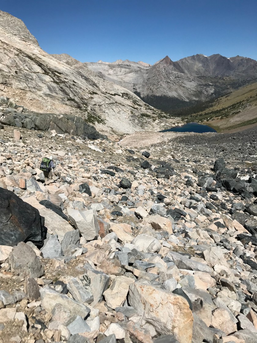
The descent down from Sky Pilot is dicey for us at first. Ray does a semi-controlled slide down very loose scree and dirt to an ice field that is hard and unforgiving. It is too early for the snow to have softened. I take a slightly different route choosing piled up and very loose rocks the size of my feet. It would be easy to start a rock slide here. And then we are both on the snowfield sliding our way down. It is the only time I wish we had micro spikes as the surface of the snow is hard and it is steep enough we can’t dig our feet in very well.

It is slow going as we alternate between snowfields that haven’t softened yet and talus fields.
Eventually we are at Shepherd Lake. The going get’s easier here. It is still off trail but it is a walk in the woods (so to speak!) compared to what we just came through. Down we go into the meadows and forests of Virginia Canyon. The grasses are tall and golden and we cross the Virginia Lakes Trail but don’t see any hikers.

Alas, no trail for us though as the Sierra High Route crosses the trail and then it goes back up cross country towards Soldier Lake. We head up towards Soldier Lake where the route climbs 1200 feet in a mile. Just below 10,000 feet we pop out of the trees and hike up rounded slabs of granite crisscrossed with fractures. The slabs look like large fish scales. This is a perfect example of exfoliation. Exfoliation occurs when rocks that were previously buried deeply have a release in pressure from erosion of overlying rocks. This release in pressure causes the rocks to crack and produce expansion joints. Such “onion-skin” style weathering is common in granitic rocks.

We are at Soldier Lake by mid-afternoon but decide to stop for the day as we aren’t scheduled to be picked up in Twin Lakes until the day after tomorrow and have plenty of time to get there.
It is a gorgeous lake and like much of the Sierra High Route, feels remote and peaceful. Tomorrow we will be crossing over the hardest pass on the Sierra High Route but for now, we enjoy the break.
Video of the Day: Sky Pilot Col