


Daily Neet Beat
The mountain gently cups the moon before the the moon dissolves into its shadow. What a glorious night camping at upper Palisade Lake! We had a full moon last night and Ray gets great pictures of it and the planets. We found chips of obsidian (a black glassy mineral) at our campsite last night which does not occur here and appears to be flakes from someone in ancient times making a projectile point or arrowhead. Signs again at very high elevation.
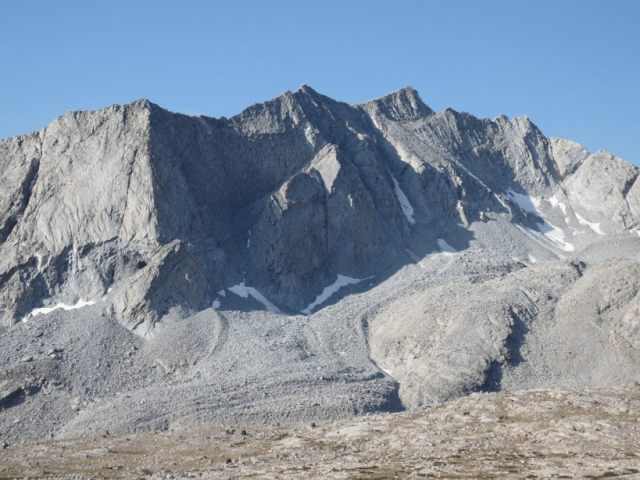
We start our hike early today as we have 2 mountain passes to ascend and about 15 miles to cover. The lighting is best in the morning and the mountains glow as we climb up and over Mather Pass. We are at the top early and it is still cold at 12,100 feet. We talk to Ron at the top of the pass, a 49-year old guy from Portland who was going to hike the John Muir Trail but is now planning on existing out the Taboose Pass Trail to Big Pine, CA. He is suffering from plantar fasciitis. It is amazing how many people we have met that don’t make it. I am glad that my ankle has healed and I feel comfortable in hiking 15 miles. As we go down, the valley on the other side opens up and has a very different character although still glacial in nature. Erratic boulders have been left behind by the glaciers that melted and we pass a picture-perfect rock glacier on the north side of an unnamed peak with an elevation of 12,648 feet. A rock glacier is dense glacial ice insulated by thick blanket of boulders. The pressure of the rocks and the incline of the slope allow the ice core to slowly deform. You see features of a thick liquid reflected on the surface with ridges and furrows following flow lines but it is made of solid rock and glacial ice. It looks like thick molasses dripping over a pancake (I must be hungry…).
We work our way back down 2,000 feet to the south fork of Kings River and then back up we go 2,000 feet to Pinchot Pass which is at an elevation of 12,050 feet. We pass Lake Marjorie and an unnamed lake right below Pinchot Pass. This unnamed lake has the most beautiful colors which appear to be from altered Paleozoic rocks and salt deposits. It is breathtaking on Pinchot Pass. We work our way back down to Twin Lakes and are on track with our plan..
Just the Facts
From Upper Palisade Lake to Twin Lakes
Miles: 15.1
Total Mies: 236.6
Camp Elevation: 10,541 ft
Passes: Mather and Pinchot
Photos of the Day


Lydia says the two planets and star are mimicking the mountains similar to the stone hut.