

For Ray and I, hikes don’t always go as planned and this one was no different. Our plan: hike down the New Hance Trail to the Colorado River, cross the river in little packrafts, and explore the rarely visited canyons of Asbestos and Vishnu north of the Colorado River. We also wanted to further investigate a rock unit we had seen in a drainage called “Double D” on a previous trip. Ray thought this unit could be a new geologic formation or at least a major event. Eventually we would work our way parallel upriver to Tabernacle Point, hike down to the Colorado River, paddle back across, intersect the Escalante Route, and hike back to and up the New Hance Trail. We gave ourselves 7 days.

What We Actually Did
The loop we planned was definitely a very ambitious plan. New Hance Trail is arguably the hardest trail on the south side of the Grand Canyon. Throw packrafting into the mix above a dangerous rapid, and off trail clambering through rugged canyons on the north side of the river with sheer drop offs and you got yourself one helluva adventure.
As it ended up, what looked like it would work on Google Earth in Asbestos Canyon for a loop to the east did not work. We did not have ropes and sheer walls in Asbestos Canyon stopped us. So we changed our plan and did a loop to the west. We hiked off-trail through Asbestos Canyon, Vishnu Canyon, Double D, and over to the east fork of Clear Creek. Using one of the only routes into Clear Creek from the east, we connected to the Clear Creek Trail, hiked back around through Phantom Ranch, crossed the bridge to get back to the south side of the river, up the South Kaibab Trail to the Tonto Trail East which we took to the Grandview Trail and hiked out back to the car at New Hance. Overall, we hiked 82 miles with a total elevation loss and gain of over 28,000 feet. Here is a summary by day:
- Day 1: New Hance Trailhead to Colorado River
(8.75 miles, on trail) - Day 2: Colorado River to Asbestos Canyon
(5.2 miles, off trail and crossing river) - Day 3: Asbestos Canyon to Double D Canyon
(9.9 miles, off trail) - Day 4: Double D Canyon to East Fork Clear Creek
(12.1 miles, off trail) - Day 5: East Fork Clear Creek to Cremation Canyon
(18.7 miles, on trail) - Day 6: Cremation Canyon to Cottonwood Creek
(17.9 miles, on trail) - Day 7: Cottonwood Creek to car at New Hance Trailhead
(9.8 miles, on trail and road)
Here is an overall map of our hike:

Day 1: New Hance Trailhead to Colorado River
Mileage: 8.75 (on trail)
Elevation gain/loss: 244 ft/5000 ft
Campsite: Colorado River near Papago Slide


We started off the first day around 8:30am at the trailhead. We had camped in our camper on Forest Service land east of the park so we could get to the trailhead early. There isn’t a parking lot for New Hance and you have to walk a 1/4 mile to get to the trailhead.

We put on our nano spikes and crunch into the frozen snow that greets us in the 16 degree weather. A cold start but we will drop about 5,000 feet in 7 miles to much warmer temperatures. It feels a bit weird to be carrying a boat and walking through snow.

My pack feels a little heavy but I am happy with the weight. My pack weighs 31 pounds which includes 7 days of food, 2 liters of water, a packraft, paddle, life vest, clothes, sleeping bag, sleeping pad, part of a tent, cooking utensils and other essentials. Our boats (Supai Matkats), paddles and life vest weigh in at 3.8 pounds. It’s pretty amazing you can carry a boat, paddle and life vest in your pack and still be at around 30 pounds for a full week of backpacking. It really frees up options for getting around.

and life vest
The New Hance Trail had spectacular views and the geology is mind-blowing. The trail drops quickly through the Kaibab, Toroweap, and Coconino with climbs over and around rockfalls. We travel along the edge of the Redwall Limestone cliff for about a mile until we get to the way down through. It seems to always be the Redwall controlling movement through the geologic units.
Eventually we work our way down into Red Canyon. The views from this hike are incredible. The red rocks of the Hakatai Formation glow chile red with a hint of flourescence.
Once we are at the Colorado River we walk up canyon for about a mile. Tomorrow we will paddle across the river in our little boats. We need to be well above Hance Rapid which is one of the most dangerous rapids on the Colorado River. We find a beach below the Papago Slide and camp for the night.

Day 2: Colorado River to Asbestos Canyon
Mileage: 5.2 (off trail)
Elevation gain/loss: 1004 ft/328 ft
Campsite: Asbestos Canyon

Well, we didn’t make many miles today but we definitely had our challenges. The first order of the day is to get across the Colorado River in our packrafts. We hiked upstream of Hance Rapids yesterday to make sure we can get across the Colorado River without going into the rapid. It is one of the most dangerous rapids. In fact, two days after we were here, a woman drowned in Hance Rapids after falling in the water while on a private boating trip. It demands respect.

We cross without incident, although it is hard to find a good place to take out on the north side of the river. After ferrying and drifting down for about a 1/2 mile, we pull into a pool above a large rock and get to land.

Once we are across and packed up, we start hiking downriver. We thought getting across the river would be the challenge for the day. But, no. Soon we reach what turns out to be the most challenging part of the day: getting around the diabase dike.

Yesterday we admired the diabase dike from afar as geologists: a striking display of magmatic activity and cross-cutting relations. The diabase dike cuts through the Hakatai Shale (hence is younger) but does not cut through the overlying Tapeats Sandstone (so the diabase dike is obviously older). It is a classic example well photographed and loved by geologists. It is striking to see in person.
But right now I am not loving the diabase dike and the geology as we view it up close and personal. It now hindering our forward progress. We need to get around the diabase dike and only have two choices: climb up about 20 feet almost vertically or scoot through in the water on a 1-foot wide ledge that drop offs into the raging and out-of-control monster of Hance Rapid.

Not being rock climbers, we make the choice of the ledge. To lessen our chances of imminent death, we leave our life vest on and undo the belts on our packs. If we fall in, at least we can get rid of the pack quickly and with a life vest, have a chance of getting through the rapid without drowning.
We both make it through with a little jump at the end. Now, that was exciting!

The rest of the day is spent climbing up above the basement rocks to get into Asbestos Canyon. We find the old mining trail, old equipment, and walk through some of the old waste rock below the Hance Asbestos mine.


There is some cliff exposure as we round the corner into Asbestos Canyon. I think Harvey Butchart might have called it “airy” but maybe not “sporty”. You definitely do not want to fall in this area. I hear Ray using colorful language and I am reminded that he doesn’t care for hiking thin ledges above large drop offs. I just pretend there is not a 500-foot cliff below us. What was I thinking when I planned this trip? I think I want to be reincarnated as a person who drinks margaritas on a beach. Hopefully not too soon. These are my thought as I gingerly tiptoe around the ledge.


Once we are in Asbestos Canyon, we relax. It has been a challenging day. Only 5.2 miles but with ledge walking above cliffs, potential to fall into a rapid, and crossing the Colorado River in little boats, it has been “epic”. We pass by an old homestead, probably built by John Hance and find a place to camp on a terrace.

There is perennial water here, and it feels like true wilderness. I feel the peace of the place and think: this is why I do this. The stoic rocks permeate me and the frogs in the creek beat a gentle chorus with my heart. Maybe I was a little too quick to ask to be reincarnated as a beach-going alcoholic.


Day 3: Asbestos Canyon to Double D Canyon
Mileage: 9.2 (off trail)
Elevation gain/loss: 2,241 ft/2,331 ft
Campsite: Double D Canyon

Today will be another tough hiking day. First we will hike out of Asbestos, cross a saddle and drop into Vishnu Creek. Then we travel through very rugged and dry country to get to Double D Canyon. No trail anywhere to be seen, mind you. We know there is water in Vishnu Creek but after that, very dry. Between Vishnu Creek and the east fork of Clear Creek are 16 miles of off-trail, very tough hiking with no water. This is challenging country and we will have to dry camp tonight, hopefully at Double D Canyon.

But it is exciting too. Ray has wanted to go back to Double D Canyon since we crossed it on a hike from Nankoweap to South Kaibab six years ago. Double D (for “Disappointment”) is about 9 miles from Asbestos and about a 1/3rd of the way between Vishnu Creek and Clear Creek. On our hike from Nankoweap six years ago, we looked at a geologic deposit down canyon as we crossed Double D. It was right on top of the Great Unconformity and looked like a jumbled mess. Maybe a new Formation? If not, what large scale event did it represent? We were curious to find out. As geologists, this meant getting our hands on it and seeing it up close.


So we begin the hike out of Asbestos Canyon. We hike up a beautiful side canyon with some flowing water and up towards and over a saddle. Ray spots a few bighorns that I miss as they speed off when I round the corner.

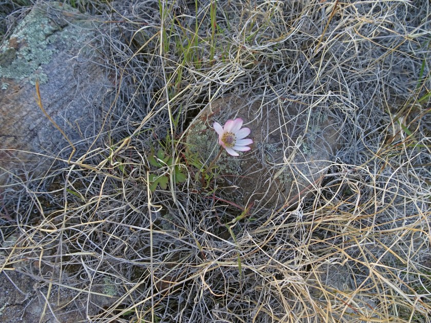
We work our way down into Vishnu Creek. We have to go up creek farther than expected (drop offs right at the creek) but get there eventually. We take a long break at lunch and camel up with water. This is the best water I’ve ever tasted! It is really good with a hint of sweet organic aftertaste.

I go off to pee and look up. OMG – there is a roasting pit right above us! I have been fascinated by roasting pits we have seen on the Esplanade Plateau farther to the west (see our Hayduke Trail Day 35 hike here). Roasting pits were used by our Native American ancestors several thousand years ago. They are donut-shaped with a ring of fire-burnt Kaibab limestone rocks.
Foods were placed in these roasting pits on heated rocks and then were covered with grasses or other vegetative matter and soil. I wonder what they roasted here, maybe agaves? The oldest dated evidence for a roasting pit in the Grand Canyon is 1460 to 1410 BC when small game hunters and plant gatherers from the Late Archaic were in the Canyon (described here). I think some of them could be much older.

Ray and I look around and see more evidence of previous use: a few pieces of pottery and flakes. Previous use of this area is not surprising. Vishnu Canyon has water, cottonwoods trees and other signs of life in an environment that, at times, can be ruthless.

We add 5 liters of water to our packs at Vishnu Creek and are weighted down with an additional 11.5 pounds as we work our way through the maze of prickly pear cacti and black brush. At one point, the 3-liter bag of water comes off the top of my pack and starts rolling towards the cliff edge. I surprise myself as I run fast across the landscape to grab it with a heavy pack. The adrenaline of potentially loosing my water and putting myself in danger gives me speed I didn’t know I had. I catch it, tie it down tightly, and breathe a sigh of relief.

By late afternoon we drop into a drainage that leads us right to the Double D Canyon and the geologic puzzle we have come to see. We spend sometime here arm-waving. It is a massive deposit of what looks like Shinumo Quartzite blocks in the Tapeats Sandstone. The deposit is larger than what we have seen in other places at the base of the Tapeats.

We have seen evidence of localized streams that left cobbles in the Tapeats sea or a few blocks of quartzite that have fallen off an ancient island. But this deposit looks like a huge event in the geologic history. Was it from landslides? cliff failures into the Tapeats Sea? Multiple debris flows? High-energy tsunamis? We ponder the meaning as the light starts to fade. After much brain damage, we work our way into the bottom of Double D canyon and set up for the night. I go to bed thinking about what might have happened here a long time ago, when the Tapeats Seas were lapping up against the edge of the continent.

Day 4: Double D Canyon to East Fork Clear Creek
Mileage: 12.1 (off trail)
Elevation gain/loss: 2541 ft/2331 ft
Campsite: East Fork Clear Creek

Last night was a dry camp as we had no water in Double D Canyon. I used 1 liter of water for dinner and 1 liter for breakfast. I used about 1/2 liter of water yesterday afternoon after leaving Vishnu Creek with 5 liters of water. So, I have 2 1/2 liters of water that have to get me to the east fork of Clear Creek, at least 12 miles away. It feels like it will be hot and dry today. Ray is in a similar situation. We know we can make it on this amount of water, if it doesn’t get too hot, and we remain strong and healthy while hiking. But there is a little stress that comes with being this far away from a water source in the desert.

We begin early to beat the heat. It’s hard to believe it was below 20 degrees Fahrenheit when we started at the south rim. It suddenly seems like we are in summer. We start working our way along the Tonto platform.

Without a trail and with cacti and black brush, you have to pay attention to every step. Sometimes we end up walking on high angled slopes as we work our way around drainage heads. My arch is hurting under my left foot and I know a big blister has formed. The Trailblazer insoles from Superfeet do not work for my feet. Unfortunately this is the second time I have learned this lesson. I put the thought of my foot pain out of my mind as I know I have to make it to water no matter what.


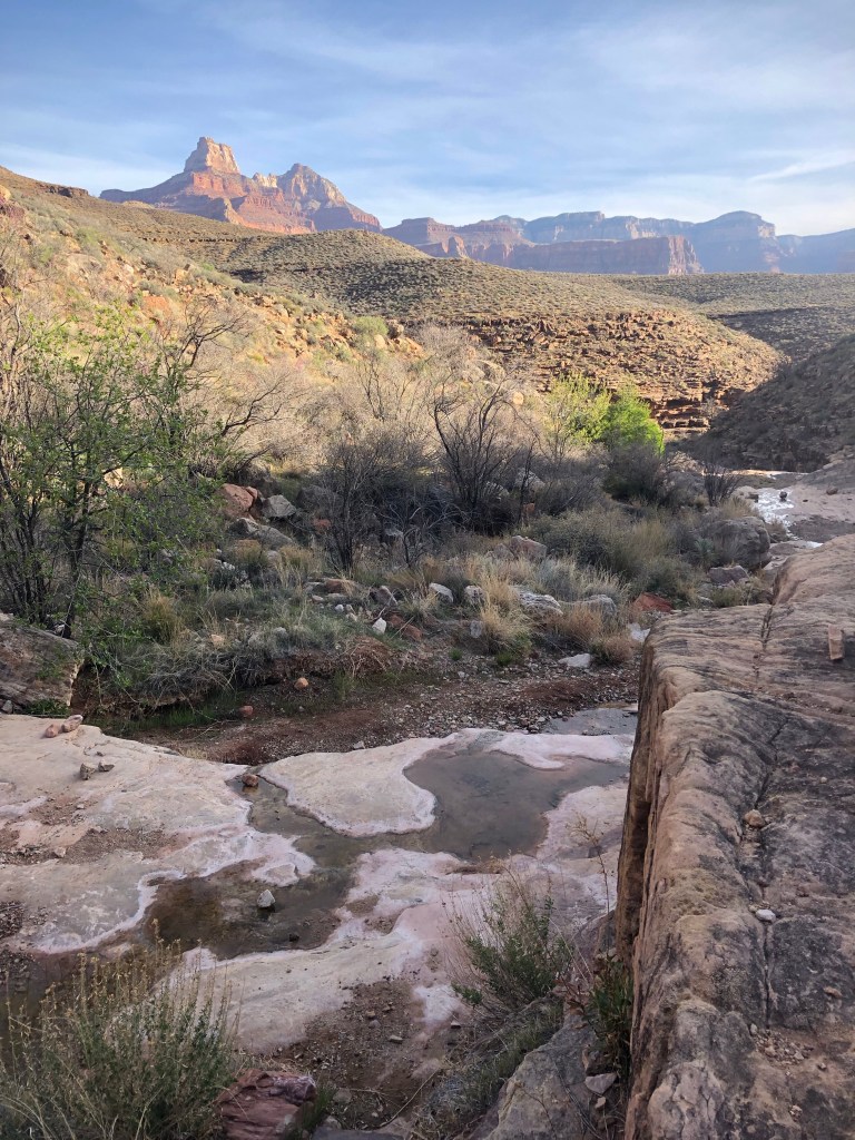
By late afternoon we are working our way towards the east fork of Clear Creek and the “sneak route” we know will get us into the canyon. It is an ancient route first used by Native Americans and is the only way into Clear Creek in this area through the cliff-forming Tapeats Sandstone.

Luckily we know it, having been here before. Memory (and gaia gps) serve us well. I am down to less than a 1/2 liter of water. We drop down and I marvel at seeing running water. I breathe a sigh of relief and Ray and I gorge ourselves on the delightful water. This water is better than the Chocolove dark chocolate bars (with almond butter filling) I love so well. I am overcome with emotion and grateful for the water that fills my belly. I sleep well that night, knowing we will intersect the Clear Creek Trail early tomorrow. After that, it is “just” trail miles.


Day 5: East Fork Clear Creek to Cremation Canyon
Mileage: 18.7
Elevation gain/loss: 3050 ft/3278 ft
Campsite: Cremation Canyon on Tonto Trail East

Last night we camped at a beautiful spot in the upper east fork of Clear Creek. I am a little concerned because we are now off track with our backcountry permit and will be traveling through a very high use area at Bright Angel. We did get walled out in Asbestos Canyon which is why we modified our plan from our approved permit. I’m sure we will see rangers today, Bright Angel Campground will be full, and the National Park Service will check for permits. So we won’t be able to camp there.

We discuss whether we should stop in the Clear Creek use area (2 miles from Phantom Ranch). It is only 9 miles away and we only have 3 days of food to get back to the car so we decide against this option. We also ponder whether we should just try and hike out to the south rim on the South Kaibab Trail. We could make it out tonight but it would be a very long day, it would be dark and cold, and we would have no ride to get back to the New Hance trail, about 15 miles down the road. Where would we camp if we took this option?

We know we must get out of the popular corridor that includes Bright Angel and South Kaibab Trails and to one of the primitive, or wild use areas to camp. We decide to try and reach the Cremation Creek area on the Tonto Trail East. This will make for a very LONG day but will get us out of the high use area. It means hiking about 19 miles but most of it will be on a trail.

So that is what we do. First we hike down through the narrows of the beautiful east fork of Clear and and then up the main fork of Clear Creek. It is such a serene area and the creek is clear and running strong. I am surprised that we see no one at Clear Creek. This is a moderately popular area and not too far from Phantom Ranch and Bright Angel campground.


We start the 800-foot climb out of Clear Creek and onto the plateau. I get into a rhythm being on a trail and it feels very relaxing. I am ignoring the raw, torn-up underside of my foot that really didn’t care for the off trail, side angle hiking. Though my mind quite liked it. I really enjoy the remote and wild feeling of places rarely visited.

By mid-morning we have reached Phantom Ranch. There are a lot of people here: runners, backpackers, day hikers and people staying in the cabins. Everyone seems happy. Getting to the bottom of the Grand Canyon is a bucket-list item for many people. I get in line for lemonade. I’d be lying if I said I hadn’t been thinking about this lemonade all morning! After the last few days of hot, dry hiking and limited water, a cold lemonade with ice sounds like heaven.
I must have looked bedraggled. The guy in front of me in a white t-shirt gives the cashier a $100 bill and says to pay it forward by buying everyone in the line lemonades until the money runs out. I benefit from his kindness and I am speechless with gratitude. I manage to squeak out a thank you. Mr. White T-Shirt starts a cascade of kindness and pretty soon everyone in line is paying it forward. Free lemonades probably lasted the rest of that day at Phantom Ranch. Kindness and lemonades can be contagious I think to myself.

After Ray and I tanked up on lemonade and water, we eat lunch under the trees by Bright Angel Creek. It is about noon, but we still have at least 6 miles to get out of the corridor and high use areas. It is starting to get hot, and the NPS recommends that people not hike between 10am and 3pm in the Grand Canyon during the summer. It is not summer but it is hot down at the bottom of the canyon and is expected to reach 90 degrees Fahrenheit today.

I am uncertain if it is the right thing to do but Ray and I decide to keep hiking even though it is in the heat of the day. I soak my shirt and hat in Bright Angel Creek and we go back across the Colorado River but this time on a bridge, instead of our little boats.

We start the the steep 1500-foot climb to Tipoff Point and Tonto Platform on the South Kaibab Trail. The wet shirt and hat kept me cool for about a half hour. Then I feel the heat of the dark, ancient basement rocks of Vishnu Complex and the sun sucking my shirt dry. My body heats up. We reach Tipoff Point and I am surprised to see a new shade shelter. Ray and I use it to take a snack break and then head on the Tonto Trail East towards Cremation Canyon.

Last time we had been in eastern-most fork of Cremation Canyon, there had been water down canyon. It had been in early March of 2019. But no such luck this time. We arrive at this fork of Cremation Canyon late afternoon and the drainage is completely dry. Luckily we brought enough water from Bright Angel to get us through and know we will find water tomorrow about 3 1/2 miles away at Lone Tree Canyon. But it is a dry camp tonight. I go to bed dreaming of the lemonade I had earlier today and the kindness of strangers. It gets me through the night.

Day 6: Cremation Canyon to Cottonwood Creek
Mileage: 17.9
Elevation gain/loss: 1222 ft/1018 ft
Campsite: Cottonwood Creek at the bottom of the Grandview Trail

It is day 6 and we need to cover some miles today. Ray and I only have two days of food left. We are about 35 miles away from our truck if we take the Tonto Trail East to the New Hance Trail and back out to the car. We could take the Tonto Trail East to the Grandview Trail and out, and walk the road to the vehicle. That would be 26 miles. Either way, we have to get our move on.

We don’t have water this morning at camp but are started by 6:20am and only have 3 1/2 miles to Lone Tree Canyon where we know there is water. We pass a group of six people going the opposite direction. Five of the six people look to be in their mid 70s. They started at Grandview Trailhead and are on their way to Indian Gardens and then out Bright Angel Trail. They camped at Lone Tree Canyon last night and confirm there is good water. It gives me hope that maybe we too can be doing this in our mid 70s.
We get to Lone Tree Canyon and man, the bugs are bad! There must have been an emergence of midges in the past few days. I throw a headnet on and fill up my water. Soon we are on our way.

The Tonto Trail East is a good late winter/early spring hike and usually has water this time of year at Lone Tree, Grapevine and Cottonwood Canyons (NPS Brochure). Our next water source will be at Grapevine Canyon, about 8.7 miles from here. I remember Grapevine from the last time we did this hike. It is a beautiful canyon but it feels like you are winding around it for half a day.


By late afternoon we have reached Cottonwood Creek below Horseshoe Mesa and the Grandview Trail. We see about 30 people camped along the creek and I am surprised by how many are here. It is a perennial water source and only about 4 miles down from the Grandview Trailhead. I guess this is becoming a backup for those who can’t get permits at Indian Gardens and Bright Angel on the main corridor.

I am also surprised by how much it has changed. The canyon has flashed within the last year and the creek bed has been scoured out and filled in with rocks and mud. The debris flow has changed the nature of the canyon. It is very different from when we were here last time in 2019.

Much as I want to push on, I can’t. We have hiked about 18 miles and the arch under my left foot has been chewed raw. I have put the pain aside but when I take my sock off and see the bloody mess my foot has become, I suddenly have all the feels. Ray wonders if we should use the mini Garmin Inreach and call for help as it looks like it may be infected. I tell Ray I think I can make it out Grandview the next day so we set up camp.

That night after we are in our bags drifting to sleep, the wind decides to test us. It hurls itself down the canyon, throwing branches and trees hither and wither. It pops out our guy lines on the tent, and one of the trekking poles holding our tent up collapses inward. Ray jumps up to fix it. I barely open my eyes I am so tired. The wind caterwauls tunelessly for 3 hours straight and then, just like that, it stops. All is quiet.
Day 7: Cottonwood Creek to car at New Hance Trailhead
Mileage: 9.8 (Ray)/5.0 (Kerrie)
Elevation gain/loss: 3884 ft/393 ft
Campsite: back at car

We decide to hike out Grandview. I will wait at the Trailhead and Ray will walk the extra 4 to 5 miles along the road to get the vehicle at New Hance. My foot looks a little better after the thorough cleaning and antibiotic treatment last night (yes I did finally use one of those packets that comes in the first aid kit). But, I know it needs some care to heal.

We are at the trailhead by 11:30am and Ray takes off to get the vehicle. The Grandview Trail starts at a very popular overlook (Grandview Point) where you can see the Colorado River off in the distance to the east. I reflect on the trip and people watch while I am waiting. It is a big contrast coming from wild and untraveled canyons on the north side of the Colorado River to the hustle and bustle of a popular spot on the south rim. I am grateful to be able to go the places I do and experience the raw, unfettered canyons with their peaceful echoes. I also hope others, who view the canyon differently in time and space than me, appreciate it for what it is. I am glad people can access it in the ways they can.
holy moly what an adventure. The Grand Canyon is one of my favorite places in the world!
PS – I hope your foot is doing better. UGH.
It sure was! I am still recovering. Definitely one of my favorite places too.
Wow, what an epic trip! Thanks for the details. Saw Last Chance about 4 years ago. Nice to know Ray evaluated it and recommended reroute. Appreciate your wait at Grandview as sightseers strolled by, having just done 82 miles.
Thanks Brian! Yes, Ray was happy when they rerouted the trail based on his suggestions. It is an interesting area.
Wow. What an adventure … you are a great story teller and the pictures are stunning!
Thank you Kyle!! I love some of Ray’s pictures from this trip.
Wow! Quite the adventure. But I knew you guys are amazing!
Thanks Jan!
Fabulous! Thanks for sharing!
Sure! Hope you are enjoying yourself in AZ!!
Kerrie, I so enjoyed reading every word of your blog. It is so cool that you and Ray can do these trips to satisfy your never-ending intellectual curiosity and desire to be in wild places. Thanks so much for sharing! I’m going to do the civilized hike from the South Rim to the North Rim via Phantom Ranch in mid-May, and reading this made my anticipation of that journey even more delicious!
Barb, you will have the time of your life. There is nothing like the Grand Canyon, hiking it rim to rim, and experiencing it from the top to the bottom.
What an amazing trip! Thanks for sharing your stories and photos–especially appreciate the interpretation of geology and plant ID. Happy trails, hope to see you this year! Tracy says Hi too!
Karen Garcia
Thanks Karen! Hope to see you guys soon!
What a great adventure! I am quite certain you will be doing hikes in your mid 70s, although they may be a little less risky and strenuous. Perhaps then maybe I can come along…
Maybe, as long as we don’t fall off any ledges!!
Great trip and writeup! Came across via reddit while looking for ideas for a trip with my wife. This looks really fun. I love the idea of exploring across the river. We have hiked down New Hance and up Grandview in 2016 with our 3 kids (then 11, 13, and 17). Fortunately we scheduled a rest day at the bottom for Day 2!
Hi,
I really enjoyed reading about your trip, that hike north of the river sounded particularly adventurous and wild – and carrying packrafts- wow, respect!
Thanks also for the geology descriptions. My wife and I are amatuers interested in geology (who wouldn’t be after hiking in the Grand Canyon and the Colorado Plateau!) but I appreciate your more informed insights. We are from Scotland and did a 5 day Boucher loop in October, which rekindled an enthusiusm for the Grand after 2 (not quite complete!) Hayduke hikes in previous years. I came across your blog whilst thinking about a route from Nankoweap-Horsethief to Clear Creek on the north of the river. That might prove to be too tough for us, but it was good to see you found a good way into the east fork of Clear Creek and that area alone looks great for a few days.
Anyway, look forward to reading about your future trips, all the best!
Brian (and Martina) aweewalk.blog