


Route: This loop hike is located in western Grand Canyon on the north side. It is very remote and requires experience and knowledge of desert water management and off-trail navigation. This loop hike combines the Cattle Trail route into Willow Canyon described by Todd Martin (http://www.toddshikingguide.com/GrandCanyoneering/index.htm) and traverses across the Esplanade Sandstone roughly following the Tuckup Trail to the east, where visible. The hike then exits out the Schmutz Spring Trailhead. We have given ourselves 3 days to hike this loop starting April 22, 2019.
Water Management Plan: Hiking on the Esplanade Sandstone can be hot and dry if it hasn’t rained for a few weeks. Sandstone potholes, though, fill with water after a rain and some of them hold water for up to a week, and sometimes two. There are even a few “permanent” potholes but they are few and far between. Luckily for us, the canyon had a soaking rain 4 days before we started our hike so the likelihood of having pothole water is higher. We have several of the larger potholes marked on our Gaia app and plan on looking for them near Fern Glen Canyon. Also, on a past hike in the first week in May, we found pothole water in a side drainage near Cottonwood Canyon and will look for water there. If there is no pothole water, there are two springs we will pass: Willow Spring and Cottonwood Spring. These springs are considered to be unpalatable, mineralized and “will likely cause short-term gastrointestinal problems” (https://www.nps.gov/grca/planyourvisit/upload/Tuckup_Trail.pdf ) If necessary, as a backup, we will drink from them.
Daily Neet Beat
Day 1: miles: 11.8, Elevation gain/loss: 512 ft/2316 ft, Camp: side drainage of Fern Glen Canyon on the Esplanade Sandstone

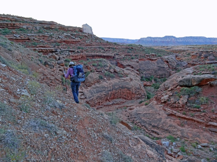
We camped in the Pinyon Juniper forest last night where the old road to Willow Canyon is blocked off, 14 miles in from the Mount Trumbull Road and about 2.5 miles away from the Schmutz Spring Trailhead. Of course we get an early start, when the morning is gray and the sky is not blazing hot. It is cold. Between the swing in temperature from night to day, the drop of several 1000 feet, and the expected high pressure system, we know we will be hot later. But for now, our fingers are numb as we brush through silver/green sages with dewy moisture. We have to walk this old road for about 5.5 miles and then cut cross country for about 1.5 miles before we reach the rim of the canyon.

The road is non-existent in the trees and is barely discernible through the sage where the only real difference is the size of the sagebrush. The last few miles we need to use navigation skills and equipment to get to the right spot.
We get to the rim and find the cairn that marks to route down into the canyon.

It really is the last cairn or sign of the route until the debris slope below the Coconino Sandstone where the slope begins to flatten out through the red Hermit Shale. This trail has not been used by ranchers in more than 65 years and is very rarely used today. There are a few canyoneers who use this route to get to or from technical climbs of slot canyons but that is it. We follow Todd Martin’s description of the route in Grand Canyoneering which provides good general and accurate beta. The drop through the Kaibab Limestone (https://en.m.wikipedia.org/wiki/Kaibab_Limestone) is straightforward but steep.

The real key in coming down from the top is to veer left after getting through the Kaibab Limestone and stay high in the Toroweap Formation https://en.m.wikipedia.org/wiki/Toroweap_Formation until you see the debris slope through the Coconino Sandstone https://en.m.wikipedia.org/wiki/Coconino_Sandstone. It is easy here to want to go straight on down through both Kaibab and Toroweap as the rubble slope goes down to the Coconino Sandstone. But what you can’t see is the cliff in the Coconino Sandstone. If you drop down too low, you end up traversing left over steep gypsum mud slopes with much more exposure than if you stay high in the Toroweap Formation. It is a steep route and precise, and really should only be attempted by strong hikers with good navigation skills and desert experience.

As we are going down this route I try to imagine driving cattle and taking horses down here as the cowboys did many years ago. Did they lose a lot of cattle who ended up sliding off a cliff? Was it a better route back then? There is so little sign of the trail except for the cairns at the bottom and the big cairn at the top. It seems like there would be more sign of a trail if it was used to drive cattle. But maybe the herd was small. Or maybe it was so long ago, more debris has covered the slope and the trace has been lost.

We get to Willow Spring mid to late morning. It is much hotter now that we have dropped several 1000 feet in elevation and the mid-day heat has arrived. Willow Spring is right on top of the Esplanade Sandstone below the cattle route.

The water from Willow Spring is considered to be poor quality. I am a hydrogeologist by training and Ray has a PhD in geology so even though we haven’t seen the chemistry data for Willow Spring we can guess why. The spring comes out at the contact between the the Hermit Shale and the Esplanade Sandstone but has probably worked it’s way through the Toroweap Formation. The Toroweap Formation contains gypsum (calcium sulfate) and other salts deposited in a shallow sea along the coastline 275 million years ago. As the water moves through the Toroweap Formation, it dissolves these salts into the water. The gypsum layers are thick here which may mean high sulfate in the water. High sulfate in the water causes diarrhea hence the “gastrointestinal problems” mentioned by the Park Service in their handout.

Ray and I assess our water situation. We did not see any pothole water from above as we came down the cattle route. We have marked on the map some potholes that MAY contain water but we don’t know for sure if they do. I started off with 4 liters of water and Ray started off with 3.5 liters. I have drunk about 1/2 liter and Ray less than that. We have hiked about 8 miles at this point and it is late morning. We decide to collect 1.5 liters each from Willow Spring but keep it as dirty water, not filtered. Water from Willow Spring plus what we have could get us to Cottonwood Spring if we had to do it. We are both strong hikers and can push on in the cooler hours of the morning or evening if needed. But, we are still hoping for pothole water based on it being less than a week since a big storm. If we find pothole water, we will dump out the Willow Spring water.

We start winding our way around the sandstone hoodoos, knobs and drainages. This is familiar territory for us. We have completed over 25 backpacking trips on the Esplanade Sandstone. Guess we kinda like this country!

After another 1 1/2 hours of hiking we stop to check out a pothole. If you hike on the Esplanade Sandstone enough, you learn that the bigger potholes (and ones most likely to contain water) are towards the edge of the sandstone platform farthest away from the eroding Hermit Shale unit above. The formation of these potholes are not well understood but here is a summary of what is known. There is a black film in many of the potholes, which, when hydrated from rain becomes a green mat of cyanobacteria. The cyanobacteria raises the pH of the water during photosynthesis to a point where the water begins to dissolve the silica cement between the sandstone grains.

This process enlarges the pothole. The biomat also, presumably, seals the pothole, allowing it to retain water longer than the surrounding sandstone. This is so fascinating to me! Why are the biggest ones toward the edge of the platform? Is it simply because they have been exposed the longest? Or, is there some unknown benefit in environmental conditions that favors cyanobacteria towards the edge? To what extent does mechanical weathering play into this (i.e., wind blowing sand grains away)? What about types of sandstone cement and location? Ahh, the mysteries never end.
We do a happy dance after finding water and stop early on the west side of Fern Glen Canyon around 2pm. It is early for camp but out here water dictates survival, comfort and fun, in that order. We drop our packs and set up camp. Now it is time to scamper around looking at the geology, amazing flowers, wildlife, and peer under ledges for pictographs, cowboy camps and other signs of those who came before.

After a few hours of scampering, we arrive back at camp tired but fully unplugged. It gets quiet as dark clouds begin to move in. Sometimes you can feel a storm before it begins.

The sky begins to pee on us and we debate about jumping in the tent. But the show has started and the drama is too much to miss. We binge watch the sky as curtains of dark mist march in formation to claps of thunder. Then a rainbow appears on both sides of the cloud, holding the clouds angry darkness in it’s delicate shimmering fingers.

The sun begins to set and the clouds begin to soften in hues of yellow, orange, pink and red. I can’t describe this, even with a bunch of emojis. I am overcome with wonder and amazement as is Ray.

Ray is running around as usual with his camera in hand. I snap a picture of him; a man in his element. And so am I, women in her element, except with a phone instead of a camera. But my phone is not connected to social media, the internet or anything else. It is only connected to me and my emotions in the moment. It is a wonder the phone doesn’t melt as I sizzle with the energy of the sky. I will never forget this night.

Day 2: miles: 11.2, Elevation gain/loss: 877 ft/845 ft, Camp: side drainage of Cottonwood Canyon
It is getting warmer each day. In the desert one learns to appreciate the morning time and not waste a precious minute of it. Hiking the four hours from 5:30am to 9:30am vs. waking up later and hiking four hour from 8am to noon can make a huge difference in how hot you get, how much water you drink, and how fast you travel. So we get up and are started by about 5:45am. We have hiked most of this section of the Esplanade before as we did a hike four years ago out to the Dome. The Dome is so iconic in this section of the Esplanade. You can see it for days and think it is a close walk but there is a often a labyrinth of canyons between you and it. I wonder what the native Americans thought of this prominent feature?

It is fairly straightforward on this part of the Esplanade though you don’t have much of a trail except around the heads of drainages. We pass by a drainage we call rattlesnake drainage because we explored down this drainage when we were here in early May of 2015 and found two either pink or speckled rattlesnakes. They were the same color as the Wescogame Member of the Supai Formation, more pinkish than the brownish tan Esplanade Sandstone. A rock and rattlesnake clan I suppose.

We make it to a side drainage of Cottonwood Canyon by 10am. We could probably hike out today still but decide to camp as we have found some pothole water in side drainages. It is not the best water. It has now been close to a week since the rain and the potholes are more stagnant and shallow. There is also a spring in the main drainage of Cottonwood but once again, it is considered mineralized and not drinkable by the Park Service. Some people have had gastrointestinal stress from this spring and we would probably hike out if it was our only source of water.

But we have water and time and the steep side canyons of Cottonwood beckon to us with their offer of shade and other discoveries. It’s scamper time once again.

Down a side canyon we go and what do you know – we find a spring. Unlike the main springs in Cottonwood drainage, this spring is coming out of the Esplanade Sandstone and not the contact between the Hermit Shale and the Esplanade Sandstone. It is at an elevation at least 200 feet lower.

We ponder this for a moment. Maybe it is not hydrologically connected to the Cottonwood Springs which probably picks up salts and other minerals as it works through the Toroweap Formation. The main Cottonwood Springs come out right at the contact between the Hermit Shale and the Esplanade but this spring comes directly out of the sandstone in the Esplanade.

Could this be a good water source that won’t cause gastrointestinal distress? It does look like there are some salts and calcite where it comes out of the sandstone but it looks pretty clear.

I wish we had a specific conductance or pH meter. Maybe in the future we will at least carry pH paper (Yes we are total geeks!!). We decide the spring water is worth the risk and like the looks of it better than the yellow skanky water we had collected from the potholes. Ray and I filter and drink the water. It does have a slight mineralized taste. I don’t immediately feel anything different in my stomach and neither does Ray. Now it is a wait and see if we get “gastrointestinal distress”. Our “n=2” experiment is started. Sometimes it just takes intestinal fortitude.
We have been down the main drainage of Cottonwood before but head down it once again. This time we notice some interesting larvae in the pools of mineralized water below the spring in the main drainage. They look like little trilobites from the Cambrian.

We get back to camp late in the day after exploring the main Cottonwood Canyon and several of the side drainages. It has been an amazing day with new crustaceans and a new spring (at least for us). Life is good.

Day 3: miles: 8.8 miles, Elevation gain/loss: 2,226 ft/371 ft, Camp: back at car and drive to Kanab

Today is mainly a hike back to our car up the Tuckup/Schmutz Spring Trail. We start early and soon pass the abandoned uranium mine site with it’s blue copper minerals and bat grate.

There is somewhat of a trail past the mine for a few miles but you lose it (or we did) a few miles before Steck’s Rock. Once in a while we find a cairn through the grasses but that is about it.
We get to Steck’s Rock. Steck’s Rock is a distinctive landmark which Steck describes as a “roughly cubical room-sized boulder”. I’ve also heard it called House Rock. It is early in the day and we have plenty of time so we decide to go check out Schmutz Spring. You can supposedly see Schmutz Spring from Steck’s Rock but it doesn’t look like there is anything there from a distance.

So we drop our packs and head over to where it is located. The spring is really hidden, an underground pool that does not discharge into the drainage. But it definitely has enough water if you needed it.

Ray and I ponder why it is an underground pool as we see no signs of faults, fractures or even a breccia pipe. Later we find out that a cowboy blasted it out. Now that I believe. It is nice to know it is there.

The trail is well established above Steck’s Rock into Tuckup Canyon. It is a fairly easy climb up about 1400 feet in 2.5 miles. It is one of the easier ways down to the Esplanade Platform. Soon we are up on the road headed back to the truck. We both feel fine so it looks like our experiment with the spring in the side drainage of Cottonwood worked out. Or maybe we just have intestinal fortitude. Either way, it was a great hike with a night on the Esplanade we will not forget.
Thanks! It was wonderful to see. I have always wanted to explore that part of the Canyon, but have never made it over there. Now, I think I’m too old. 🙁
Glad you enjoyed it Charles!
Two true spirits, Kerrie and Ray, relating awesome picturesque prose of their Grand Canyon travels and adventures—- Excellent! —Mom “in her element.”
Amazing to those of us who only hike on real trails! You guys are true explorers. Glad you survived all the trials. Sandi
this is an awesome/nice write up! thank you. 🙂
do you plan to post your other 25 GC hikes to this site or are they located elsewhere?
i’m a science/engineering nerd myself and appreciate your quick discussion on the potholes, CW spring water salinity, etc. i’ve theororized that the reason for the much bigger, deeper potholes on the edge of the Esplanade has more to do with weathering/mechanical forces at play there and less with cyanno-bacterial weathering. but i’m not a trained geologist/chemist and this is just my non-edumacated theory… 🙂
cheers!
paul
8 light-years north of center of universe
Thank you Paul!! I did not write up most of our other Esplanade trips. I’m trying to keep better track and notes now. I plan on writing up the Hades Knoll/150 Mile trip and probably Fishtail Mesa from last Fall. Regarding the bigger potholes near the edge, Ray also thinks it is mostly physical (and chemical) weathering and the fact they have been exposed for a longer period of time.
Thank you, I enjoyed your trip report! More places to explore!
There are always more places to explore!!
Stunning!
Yes it was. Ray takes great pictures!
I enjoyed reading about your hike/adventure and loved the beautiful pictures. Your sister Kelli shared this with her FB, hiking buddies.
Angie
Thank you Angie!
Thanks for your trip description and fine photos. It sparks old memories for me. I never thought anyone would take the Willow Cyn cattle route intentionally, but it works very well for your loop. A while back we did Steck’s Tuckup to Stairway Loop. After spending too much time in Stairway we found ourselves at Willow Spring a day behind our schedule. Steck’s description of the cattle trail and my GPS view of the old roads on the rim convinced me that this would be faster than taking the Tuckup trail back to the head of the canyon. It worked well. The route finding was pretty easy going “up”. Still it was a long walk back to the car at Tuckup trailhead. Later I found about the North route out of Willow (described by Todd) and wished we had tried that.
We did test our intestinal fortitude on that trip as we drank the water in Tuckup and Stairway. None of us experienced any pain but it was the only trip I can remember where everyone ran out of toilet paper.
Again, thanks for the memories and new loop ideas.
Charlie
Must have been a great trip. I would like to do Tuckup to Stairway (or nose by Cove Canyon described by Todd). It sounds like it gets a bit tricky in Stairway and as I recall Steck’s description was a bit simplified. Glad it brought back memories and ideas.