Me on the ridge approaching the summit of Mt. Whitney
Daily Neet Beat
Today is a big day: we are going for the summit of Mt. Whitney, the highest peak in the lower 48 states (at 14,504 feet) and the official end of the John Muir Trail. The western portion of Mt. Whitney is in Sequoia National Park and the John Muir Trail was completed by the Park Service in conjunction with the Forest Service. Most people go to the top of Mt. Whitney and then east over the Trail Crest Pass and exit out of what is called Whitney Portal. We are planning on summiting Mt. Whitney from the west side and then coming back down on the west side, heading south for another 32 miles or so (including a side hike) and exiting out of Cottonwood Pass. So we decide to keep the same campsite, climb Whitney, and come back down to the same campsite. This means we have to hike 14 miles with close to 4,000 feet elevation gain and 4,000 feet elevation loss. OK, this means an early start and we plan for a 5am departure.
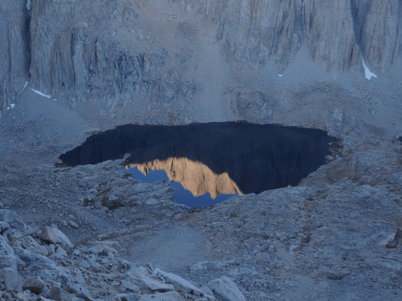
5am comes quickly and we are on the trail with headlamps in the dark. Have any of you ever hiked in the dark with a headlamp? It is like swimming in dark murky water without knowing what is around you. We hike for about an hour and as we reach Guitar Lake above tree line, the sky is light enough and we can turn off our headlamps. Guitar Lake is popular as a base camp on the west side for climbing Mt. Whitney. Guitar Lake is about 4.8 miles from the top of Mt. Whitney and is 3,000 feet below the summit so it makes for a good sunrise or hike to the top in the morning. We get beautiful reflections off of Hitchcock Lakes as we climb higher and get very close to a pika and Ray gets a few good pictures. The trail isn’t actually too bad; just a lot of switchbacks as you zig-zag back and forth up (and up, and up….). We reach Trail Crest Pass where the John Muir Trail meets the Whitney Portal trail at 13,748 feet.There is 1.9 miles to the top of Mt. Whitney from this junction. Many people leave their packs at this junction and there are packs and people lined up here. It feels a bit crowded but Mt. Whitney gets about 20,000 visitors per year so it isn’t surprising.
We reach the top of Mt. Whitney at around 8:30am and an emotional knot unravels inside of me. Ray and I hug tightly and I bawl like a baby. It is a combination of things: completing the John Muir Trail, spending quality time with my wonderful husband Ray, and being on the top of Mount Whitney in a National Park on the 100th anniversary of the National Park Service. I didn’t plan to be on top of Mt. Whitney for the 100th year anniversary but it somehow is fitting. The National Park Service has played an important role in my life. As a child, I loved going to campfire talks in National Parks. I became a Park Ranger in my 20’s and spent 5 seasons in Yellowstone National Park and 2 seasons in Katmai National Park, AK. I feel overwhelmed with gratitude that I can even be here enjoying this place. I remind everyone on the way down from Mt. Whitney (and there are LOTS of people hiking up) that today is the 100th anniversary of the National Park Service and they should be thankful that visionaries such as John Muir and strong leaders such as Teddy Roosevelt, Stephen Mather, and others had the foresight to set aside public lands (whether they be National Parks, Forest Service or BLM) for all future generations to enjoy and use. I feel very blessed to be an American from a country where the idea of a National Park came to be and which has inspired countries all over the world to do the same. I will end today with a quote from John Muir that really hits home:
“As long as I live, I’ll hear waterfalls, and birds, and wind sing. I’ll interpret the rocks, learn the language of the flood, storm and the avalanche. I’ll acquaint myself with the glaciers and the wild gardens, and get as near the heart of the world as I can”.
As I reflect on John Muir’s quote today, I feel very near the heart of the world.
Just the Facts
From 1/2 Mile Above Crabtree Meadow to Whitney Summit and Back Down to Same Camp
Miles: 14
Total Miles: 303.3
Summit of Whitney
Photos of the Day
You can see why this lake is called “Guitar” Lake
Beautiful morning reflections in Hitchcock Lakes
A fat pika
The trail on the west side of Mt. Whitney as it switches up the slope.
Congestion of packs and people at Trail Crest Pass and the junction with the Whitney Portal trail .
Ray and I on the top of Mt. Whitney. There is a little smoke haze in the distance from the fires this summer.
Celebrating 100 years of the National Park Service on the top of Mt. Whitney


Awesome pictures…thanks for sharing! Wow what a great accomplishment, and doing what you love! Congrats!
Thanks Karen!